
Built over the Tigris in 1065 during the Marwanid period, the Ten-Eyed Bridge is a rare jewel that has endured within Diyarbakır’s natural landscape to this day. Images obtained via Google Earth offer a stark summary of the ecocide unfolding around the bridge and its surroundings.
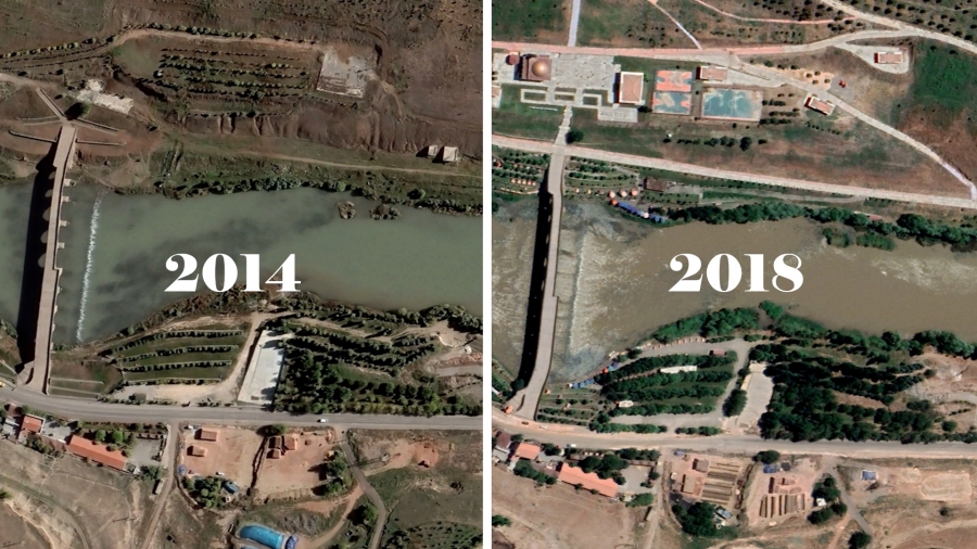
Constructed in 1065 over the Tigris River by the architect Yusuf, son of Ubayd, the Ten-Eyed Bridge—still standing today—now faces the threat of an ecocide driven day by day by human activity. A defining feature of the natural landscape formed by the Tigris Valley and the Hevsel Gardens, the bridge has seen construction on both banks begin in 2016, following the appointment of government trustees to Diyarbakır Metropolitan Municipality. Google Earth images show that while there was no development around the bridge in 2014, concrete walls began rising—day by day—after the trustees took office in 2016.
The riverbed has been disturbed
Scientific studies carried out in the area encompassing the Tigris River Valley and the Hevsel Gardens have identified around 607 plant species and close to 635 animal species. This habitat—home to birds, mammals and invertebrates—now sees many species facing the risk of extinction. Particularly around the Ten-Eyed Bridge, rubble dumped into the riverbed and the steadily rising concrete walls are, day by day, degrading the fauna of what was once described as a natural haven.
Human activity has intensified noise pollution
Business licences issued under the trustee administrations appointed to the metropolitan and district municipalities increased human activity in the area, pushing noise pollution to unbearable levels. With wedding venues among the businesses operating on the bridge, fireworks have not only altered the migration routes of some 180 bird species living in the region, but have also caused bird deaths.
Not reforestation, but ecocide
Contrary to claims by business operators—whose numbers continue to grow and whose footprint expands daily—that the area is being reforested, the years-long transformation is reflected in Google Earth image frames in a very different way.


